
Gregg Prillaman ARTICLE
Some Interesting History About Canterbury Woods
Written by Gregg Prillaman 8415 Queen Elizabeth Blvd., Jan. 21, 2022
My wife, Cindy, and I were at an open house here in Canterbury Woods a few months ago and struck up a conversation with two newer residents about the history of the neighborhood going back to colonial days and the Civil War and then when the houses were built in the 1960s. Susan DiMaina was also in the conversation and asked if I would write a piece to share with the rest of the community – particularly those folks who are recent arrivals. Susan is pretty persuasive, so I agreed.
By way of history, Cindy and I moved into our house at 8415 Queen Elizabeth Blvd. (at the corner of QE and Wakefield Chapel Road) in August of 1979 and, except for a few years overseas, have lived here ever since (42 years). We bought the house from Dalton and Auguste Bell who were the original owners. They signed the contract with the builders on March 21, 1964 to buy the lot (#114 in Phase 2) and have the house built, and took possession of the house on April 20 of 1965. The Bells left us a folder with the original sales information for the house and some marketing materials for Canterbury Woods. We also learned about the history of CW from our neighbors Bill and Betty Bowman who were the original owners of 8414 QE. Bill had always been active in the community, and Betty had been part of the sales team for the builders. When people came to the sales office Betty was one of the reps who described the development, house models, prices, options, etc. So she knew a lot about the community, the houses, and the builder. And we heard early stories from our neighbors Jack and Ann Crogan who moved into 8417 QE about 1968 with their family, including their son, Pat, who still lives there with his wife Pam. Pat grew up in Canterbury Woods and remembers clearly when houses were still being built, when Queen Elizabeth ended before the school, when all of the back yards ran together, when the two houses on Magdalene Ct. were destroyed by a gas leak, and much more.
So here are some of the things we learned from those sources and others.
Our Area During Colonial Times
The following history is drawn from a variety of books and articles I’ve collected through the years from the Fairfax County Govt. and local historical societies. Two particularly good sources are the book Annandale, Virginia A Brief History by Robert Moxham and Estella-Bryans-Munson and a pamphlet “Fairfax County, Virginia – An Historical Tour Map and Guide to Places of Interest”. I think this history is pretty accurate, but it is only a short summary. There are many other excellent sources that tell a much more complete story of our area.
The first inhabitants of our area were Native Americans who settled here about 12,000 years ago after the last ice age receded. The area was heavily forested at that time and deer, buffalo, bear, beaver, and other game were plentiful, and the rivers and creeks were full of fish and fresh water clams. Through the generations those people hunted, fished, and grew crops of corn, beans, squash, and tobacco on fields they cleared by burning large sections of the dense forest. As a whole, life was pretty good in the future Canterbury Woods.
The first European to come to our area was Capt. John Smith of Jamestown fame who sailed up the Potomac in 1608 to explore the land on both sides of the river. When Smith arrived, the main tribe living in what is now Fairfax County were the “Dogue” (also called “Tauxenent”) who lived in several villages connected by paths/game trails through the forests. The Dogue remained in the area for several decades but had left (or been driven out by other tribes) by 1664 when the first English pioneers came to settle here. Those settlers took over the Dogue villages and fields, and turned their paths into rudimentary roads. Many of those paths that became roads are still with us today, including Little River Turnpike, Braddock Road, Ox Road, Rolling Road, and Backlick Road to name just a few.
In the 1600s all of the land in Virginia was owned by the King of England, who would grant large tracts to loyal supporters who then sold the land to settlers and speculators. In 1685 King William and his wife Queen Mary (as in William and Mary University) granted more than 5 million acres to Lord Fairfax who divided the land into Fairfax County and Prince William County and started selling parcels.
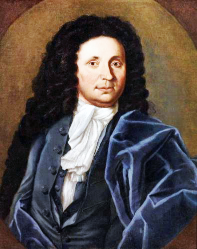
About 1690 an enterprising English lawyer and tobacco trader named William Fitzhugh (portrait below) purchased a huge tract of 21,996 acres (later recalculated at 24,112 acres) that encompassed much of what is now Annandale, Springfield, Burke, Fairfax City, and parts of Falls Church. (Canterbury Woods was kind of in the center of the parcel.) He named the tract “Ravensworth” after his family’s estate in Bedford, England, and set about leasing sections to farmers who would work the land. He had originally hoped to lease to French Protestants (Huguenots) fleeing persecution in France – potentially to start vineyards to make wine. But that didn’t work out so he rented to English and Scottish farmers who, over the course of many years, cleared the land and grew tobacco, corn, barley, and other crops. As you probably suspect, much of that work was done by slaves owned by the Fitzhughs and other farmers.
William Fitzhugh died in 1701 and Ravensworth was inherited by his two oldest sons, William II and Henry II. William got the land on the south side of Braddock Road and Henry the land on the north side, including Canterbury Woods. Tobacco was the primary cash crop at that time and the Fitzhughs grew tobacco on most of their fields – including no doubt where CW now sits. The harvested and dried tobacco was packed into large barrels that were harnessed to oxen and rolled down a “rolling road” to Alexandria or Colchester where they would be shipped to England. The Rolling Road that starts by the Kings Park shopping center was one “rolling road” and Backlick Road across the beltway was another. The Fitzhughs prospered and County records show that by 1782 Ravensworth was the fourth-largest plantation in Fairfax County – the larger three were owned by George Washington, George Mason, and Phillip Ludwell Lee.
The Fitzhughs also leased part of their land to other farmers, including one named William Payne Jr. who once got into a fight with a young George Washington on Little River Turnpike near where the Northern Virginia Community College (NVCC) campus and entrance to Camelot now sit. According to historians, in 1753 George Washington – age 21 and already a Colonel in the Virginia Militia – was surveying our area to create the town of Annandale. He got into a heated argument with Payne over rival candidates for the House of Burgesses and Payne hit Washington with a stick and knocked him to the ground. Washington wasn’t seriously hurt but his friends urged him to challenge Payne to a duel. Washington considered challenging Payne, but after reflecting on what he had said to provoke the attack he apologized to Payne and they agreed to put the matter behind them. Good thing – otherwise Washington might have been killed right there on Little River Turnpike instead of becoming the father of our country.
At this point you may be wondering where all of these wealthy Fitzhughs lived. There were 3 main houses.
Ravensworth Hall
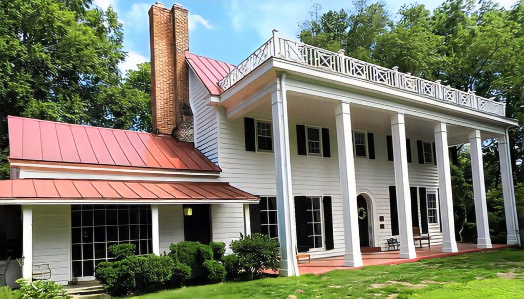
– the largest house (photo below) – was on the west side of Port Royal Road where the Ravensworth shopping center is now located. (There is a historical marker there.) The huge house, built by William Fitzhugh (great grandson of the original William) about 1796, had pillars and a two-story portico on the front, a two-story veranda on the back, spacious rooms, elegant furnishings, and an incredible collection of early American heirlooms and portraits. It was home to a wide array of Fitzhughs through the years, including the wife of Robert E. Lee who took refuge there during the Civil War. Mary Anna (Custis) Lee, a great granddaughter of Martha Washington and of William Fitzhugh, had visited relatives at the house many times through the years. In fact, she and Robert E. Lee spent their honeymoon at Ravensworth after their wedding in 1831. When the Civil War started Robert and Mary Ann Lee were living in the Custis-Lee Mansion which is now part of Arlington cemetery. The Mansion was taken over by Union forces in 1861 so Mary Ann moved to Ravensworth and stayed there for a time before moving to Richmond and other locations further south. After the Civil War the house was occupied by Robert E. Lee’s son, William Henry Fitzhugh “Rooney” Lee, who was a Confederate officer during the Civil War then after the War became a U.S. Congressman from Virginia. The house and surrounding farm remained in the Fitzhugh and Lee families until 1926 when the house mysteriously caught fire and burned to the ground. In 1957 the property was sold to a developer who built the Ravensworth subdivision. The shopping center was built in 1960.
Ossian Hall
– the second largest house (photo below) – was on the east side of Ravensworth Road about 100 yards north of the intersection of Ravensworth and Braddock Road. The beautiful, white-columned house was built about 1780 ( incorporating a smaller house built about 1730) and was widely regarded as the most elegant house in Annandale. In the 1790s the house was occupied by Nicholas Fitzhugh (son of Henry II) and his wife Sarah Washington who was a granddaughter of George Washington’s half brother. George Washington was fond of Sarah and his diary records that on Nov. 5, 1799 (after he had been President and just 6 weeks before he died) he was traveling from Mount Vernon to Difficult Run (near the Fair Oaks shopping center) to see some land he had bought and stopped at Ossian Hall to have dinner with Sarah and Nicholas. He was no doubt at Ossian Hall on many other occasions. Sadly, Ossian Hall fell into disrepair through the years and in 1958 was intentionally burned as a training exercise for the Annandale Fire Dept.
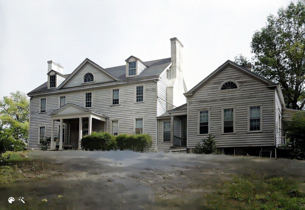
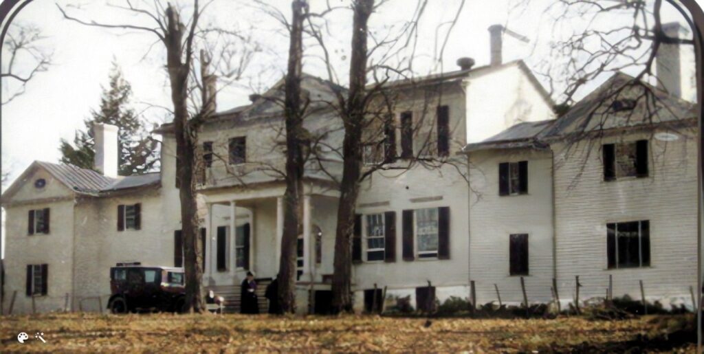
Oak Hill
– the smallest house (photo below) – is the most interesting for us because it was the plantation house for our CW area and because it is still there – near the corner of Wakefield Chapel Road and Braeburn Drive. Oak Hill was built about 1780 by Richard Fitzhugh (great grandson of William) and his wife Susannah. The house was a lovely Georgian style, four-room home with beautiful appointments. It was smaller than it is now, but the yard and outbuildings (barns, stables, kitchen, smoke house, well house, etc.) extended all the way from Little River Turnpike to Braeburn Drive. The land Richard owned included about 2,500 acres. Wakefield Chapel Road was just a farm lane that ran from Little River to Braddock Road and was used to move wagons, crops, etc. from one part of the farm to another. The area that is now Canterbury Woods was most likely in crops – primarily tobacco but also possibly corn, beans, barley, and other crops used to feed people and animals.
Richard and Susannah were friends with Thomas Jefferson and often hosted Jefferson at Oak Hill during his presidency (1801- 1809). Jefferson’s account books record at least four overnight visits at Oak Hill when he was traveling from Washington to his home at Monticello. Jefferson traveled by horse, of course, and his route came down Little River Turnpike right past Oak Hill. Odd as it sounds, in those days the trip from the White House to Oak Hill took 6-8 hours depending on how muddy the roads were so Oak Hill was a perfect place to have supper and spend the night. He most likely slept in a room on the first floor. You can imagine Jefferson having dinner with Richard, Susannah, and their 8 children and telling them about the Louisiana Purchase, the Lewis and Clark expedition, the duel between his Vice-President Aaron Burr and Alexander Hamilton, and all of the other incredible events during his Presidency. Jefferson’s last stay at Oak Hill was on March 14, 1809 when he was going home after turning the Presidency over to James Madison. Jefferson loved farming, so it is almost certain that he and Richard rode around the plantation looking at the crops, including what is now Canterbury Woods. Just as George Washington very likely rode through our area when he surveyed Annandale and visited the Fitzhughs.
The house also has an interesting ghost story that dates to the time when it was owned by Richard and Susannah. The story goes that about 1775 – before the Revolutionary War – Richard and his daughter Anne went to London on business and Anne fell in love with a British Captain named Charles “Charlie” Hawkins. Richard and Anne returned to Virginia and Capt. Hawkins was later deployed to Virginia (Dumfries) after the Revolutionary War began. In the later years of the War (early 1780s) Charlie would sneak over to Oak Hill to visit Anne. On one fateful night American soldiers were tipped off that he was there and came to search the house. Ann and Charlie hid in a secret room over the dining room which could only be accessed by a trap door hidden in the paneling of a closet. One of the soldiers thrust a bayonet or sword through the cracks in the trap door and killed Anne. A blood stain appeared on the ceiling of the dining room marking the spot where Ann was killed – and that stain reappeared over and over through the years no matter how many times it was painted over. There have also been reports of people hearing Anne calling out for “Charlie” and hearing the sound of boots going up the stairs.
Oak Hill has passed through many hands since 1780 and has been expanded into a 6-bedroom, 6-bathroom, 4,500 sq. ft. home. But the core of the original house is still there, as are two huge oak trees which gave the property its name, and a number of 20-foot boxwoods that were part of the original landscaping.
During the Civil War
The area where CW now sits was a combination of farm land and woods during the Civil War. One Union map shows tobacco growing where we now live, but other sources say that wheat, Indian corn, oats, Irish potatoes, and buckwheat were also common crops at that time. Records for the Ossian Hall farm show that it raised all of those crops during the War, and also had income from horses, sheep, dairy cattle, apples, cherries, and honey. Any of those could have been raised where CW now sits.
Annandale and our CW area were in the middle of activity from the beginning of the Civil War in 1861 through the end in 1865. Little River Turnpike, Columbia Pike, and Braddock Road were main routes for moving troops and supplies to and from a series of major battles. Our area changed hands several times during the War and was frequently the site of cavalry skirmishes between Mosby’s Raiders and Union forces. There are many wonderful books that detail all of the activity in our area, but here are a few examples I think will give our CW residents a good flavor for what we would have seen had we been living here during the War.
Battle of 1st Manassas (Bull Run) July 1861 – On Tuesday, July 16, 1861 more than 10,000 Union soldiers, with scores of cannons and supply wagons, marched up Columbia Pike and Little River Turnpike into Annandale on the way to the 1st battle of Manassas (Bull Run). They spent the night in Annandale then the next morning half of the column moved down Ravensworth Road to Braddock Road and turned west to march to Centerville. The other half marched down Little River Turnpike to Fairfax Court House and on to Manassas. The soldiers were on the road and spread out on both sides for several hundred yards, and almost certainly walked through Canterbury Woods and stopped to drink and water their horses at the creeks. Cavalry also no doubt rode back and forth on “Wakefield Road” (now Wakefield Chapel Road) between the column on Braddock and the one on Little River. The battle of Manassas took place on Sunday, July 21 and the residents of Annandale heard the cannons firing constantly during the day. One woman wrote “At six in the morning I was aroused by cannon, and from then til one o’clock there was hardly one minute between each fire. Then for half an hour it ceased, recommenced and continued til dark….I never imagined anything so terrible.” On the night of July 21 thousands of dispirited Union soldiers came back down Little River Turnpike and Braddock Road returning from the battle. “The initial trickle turned into a deluge of utterly disorganized foot soldiers, cavalry, artillery, and wagons – all headed toward the Potomac.” Once again, there is little doubt that some of those soldiers came into the area where we now live.
Mosby Raiders – Confederate Colonel John Singleton Mosby and his cavalry troop operated all over our area harrying Union forces, disrupting supply lines, capturing Union prisoners, and generally causing the Union Army as much aggravation as they could.
Their first raid in the Annandale area was on Aug. 11, 1863 when they rode east from Loudoun County through Vienna to Merrifield, then south by back roads striking the Little River Turnpike at William Gooding’s Tavern which stood on the “north side of the Turnpike at the intersection with Wakefield Road” (across Little River from the NVCC campus). They attacked Union forces near the Tavern, captured two wagon trains, and escaped down Wakefield Road to Braddock Road (right past CW) with 25 Union prisoners and a number of horses and mules.
Two weeks later, on Aug. 23, the Raiders snuck up on Union forces at Goodings Tavern and engaged in a serious cavalry battle which resulted in at least 8 deaths (6 Union ad 2 Raiders) and many wounded. Mosby was shot twice through the thigh and the side, and his troops took him down Wakefield Road to the creek by Braddock Road where they treated his wounds before taking him west to Aldie. The battle raged all over the area and Mosby and his men rode right by (or through) CW to the creek where they treated his wounds. If the Union cavalry pursued them, there were no doubt many gunshots back and forth.
One more interesting story “The Battle of Annandale” occurred a year later. On the night of Aug. 24, 1864 Mosby and about 300 Raiders brought two small cannons to Goodings Tavern (across from NVCC) and set it up on the north side of Little River Turnpike to fire across what is now the beltway to strike a Union stockade (Fort Schneider) located at the intersection of Hummer Road and Little River. The Raiders began shelling the stockade about 5 am the morning of Aug. 25 and then charged the stockade in a cavalry attack. They twice demanded that the stockade surrender but the commander refused. After firing 30 – 40 artillery shells, the Raiders broke off the attack and returned to Loudoun County. Local people said the noise from the bombardment was deafening.
With all of the activity in our area during the War, Canterbury Woods is probably littered with bullets and other Civil War era artifacts. About 1992 my sons, Ben and Zach, were digging in our front yard and found these two Civil War era
rifle bullets. As you can see, one is in tact which means it was shot but didn’t hit anything. The other is flattened from
impacting something. Other residents have told me they’ve also found bullets in their yards through the years.

Some Other Interesting Events Through the Years
Braddock Road began as a path/game trail and was first identified as a “road” about 1740 – 1745. It was called the “Mountain Road” at that time because it ran from Alexandria west to the Shenandoah Valley. It was later named Braddock Road after British General Edward Braddock who, in 1755 during the French & Indian War, led an army of British soldiers and Colonial militia down the road to attack the French at Fort Duquesne (now Pittsburg). Braddock’s army spent months chopping their way through the wilderness widening the road so the army could move it’s artillery and wagons. But they were ambushed by the French and Indians in Pennsylvania and Braddock was killed. George Washington who was second in command took over and led the army on a retreat.
- Little River Turnpike was the first turnpike built in Northern Virginia. Construction began in 1805 to carry crops and materials from Loudoun County to the port of Alexandria. The road was initially made of trees trunks laid side by side and covered with dirt and gravel to make it more passable in bad weather. It was a toll road and called a
“turnpike” because there were poles (pikes) across the road at the toll stations that were turned or lifted after the traveler paid the toll. - Columbia Pike was built in 1808 by merchants in Washington, DC and connected to Little River Turnpike in Annandale to divert some of the commerce with Loudoun County to D.C. rather than Alexandria.
- The Wakefield Chapel east on Tollhouse Road near NVCC was built in 1897 as a Methodist Church. Was
taken over by the County in 1977. - The first automobile was driven in Annandale in 1904.
- The first telephone service came to Annandale in 1916
- The Annandale Volunteer Fire Dept. was organized in 1940
- The Annandale Campus of Northern Virginia Community College opened in 1965. They tore down a
grand plantation house named Chestnut Hill to build it.
The Building of Canterbury Woods
When Canterbury Woods was built in the 1960s Fairfax County was exploding in new housing developments. The beltway and 395 were still being built and if you drove west down Braddock Road – which was just one lane in each direction until about 1975 – you saw “New Homes” signs on every corner. CW was one of dozens of new developments competing for buyers.
CW was built by Hyman Bernstein & Sons in 6 Sections, as described in “Remembering the Early Years of Canterbury Woods” by Mary Ann and Jim Shepherd in the July/Aug 2015 CWCA Gazette.
- Section 1: by the pool off Braddock Road
- Section 2: Wakefield Chapel Road
- Sections 3 & 4: Queen Elizabeth Blvd. and branching streets from Wakefield Chapel to the second King Richard intersection
- Sections 5 & 6: Completing Queen Elizabeth finally enabling school children to walk to CWES
The builder offered 7 house models, as shown below with base prices for 1965. The marketing sheet for each model is also attached, but because they were printed in colors (e.g. yellow writing on blue paper) they are hard to read. (Susan DiMaina has the originals.)
- King Henry $23,990 split level with double-door entry on the lower level
- Queen Anne $24,900 rambler with two full day-light living levels
- King John $25,490 colonial with kitchen & living room on the upper level
- Prince of Wales $26,490 rambler 70 feet long with kitchen & living room on upper level
- Duke of Burgundy $26,490 colonial with five columns across the front and split foyer entry
- Queen Elizabeth $26,490 classic split level with entry next to kitchen on main level
- King Richard $27,990 center-stair 2-story colonial with 1-story library at one end
Here is how the community was described in the marketing materials:
Some Options you could add:
- Corner Lot $250
- Basement $2,000 unfinished
- Carport $795 single, $1500 double
- Garage $1500 single
- Central AC (gas) $1395
- Fireplace $650
- Intercom System $225
- Upgraded new brick $250
- Antique used brick* $350
* Per Betty Bowman, the antique used bricks came from warehouses in Alexandria built in the 1700s and 1800s that were being torn down to make room for new buildings. It was priced higher than new brick because it was hand-made and had to be hand-cleaned to be reused. The builder had gotten a good deal on thousands of those old bricks and used them in CW and other houses in the area.
If these prices seem incredibly low, you have to remember that in 1965 the median family income in the U.S. was $6,900, the average new home in the D.C. area was $20,000, and you could buy a new Mustang convertible for $2,700. So adding $2,000 for a basement was a lot of money.
Ad for the King Richard model in March 1965 Washington Post
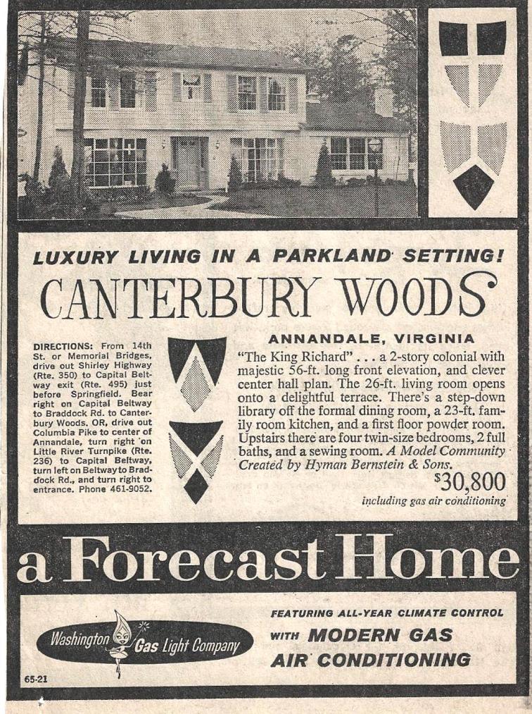
The total 1965 purchase price of our King Richard house at 8415 QE as:
- Base Price: $27,990
- Corner Lot: 250
- Fireplace: 650
- Intercom System: 225
- Antique Used Brick: 350
- Closing Costs: 750
- Total Price: $30, 215
The 30 year FHA mortgage interest rate in 1965 was 5.25%, and a typical monthly mortgage payment was about $190
The name Canterbury Woods came from the national obsession in the early 1960s with medieval England flowing from the popularity of the musical Camelot. The name “Camelot” was already taken by the Camelot subdivision on the other side of Little River Turnpike, so Bernstein named our development after Chaucer’s
“Canterbury Tales” and gave most of the streets British names like Queen Elizabeth, King Richard, Chanticleer, Southampton, Blackpool, and English. He named others, according to Betty Bowman, after characters in mythology or ancient history like Sinon, Hercules, Midas, Centaurs, Cicero, Nero, and Ganelon – and he named some after his favorite books and movies like Fleming after Ian Fleming who wrote the James Bond books and Ponderosa after the ranch on the TV show Bonanza.
The area where CW now stands was mostly farm land in the 1700s and 1800s with copses of trees here and there. But the land was too depleted for farming by the early 1900s so it was allowed to return to natural woods. It was almost entirely wooded when CW was built and hundreds of trees were cleared. But Bernstein left as many original trees as possible in the park areas and around the homes. When we moved into our house, for example, there was a hickory tree in the front yard and an oak in the back yard that were saplings during the Civil War. There were old hardwood trees like that all over CW, as well as a huge number of pines, cedars, and hollies that were 60-80 years old. Many of those have died through the years but there are still a number – like the huge oak in our back yard – that were part of the native forest. When we moved in there were also dozens of ornamental flowering cherry trees all along both sides of Queen Elizabeth and some side streets. I don’t know whether they were put in by the Board or by the individual home owners, but when they bloomed in the spring the street was gorgeous!
As is the case today, a large percentage of the original owners in CW worked with the Federal Government or Federal contractors. The government and contracting firms were expanding dramatically during the 1960s to support the Cold War, the Vietnam War, and other government programs. And a great many CW residents were WWII veterans. Bill Bowman, for example, was a retired Air Force Colonel who had flown bombers during WWII and B-52s in the 1950s, Dalton Bell was in the Navy during WWII and his wife was a German war bride, another neighbor had served in Patton’s 3rd Army all the way from Normandy to Berlin, and there were many more.
Betty Bowman told us an interesting story about the Chapel Hill development across Wakefield Chapel Road. Apparently, Hyman Bernstein had a falling out with his sons when the last stages of Canterbury Woods were being built. So the sons bought the land across Wakefield Chapel Road and declared they would build a much nicer development to show up their father. So they built Chapel Hill in the early 1970s with a lake, buried utilities, and larger, grander homes. Betty was also a sales rep for those homes and said most sold between $35,000 and $40,000 in the early 1970s.
I hope the other residents find this history interesting, and I would welcome any stories or anecdotes they may have from the early days. I would particularly like to see (and scan) any photos people might have of Canterbury Woods when it was being built in the 1960s and early 1970s. I don’t have photos like that and would very much like to add them to the community history.
K Gregg Prillaman (1/21/2022)
8415 Queen Elizabeth Blvd.
kprilla150@aol.com
703-239-2156